Drones for Underground Mines
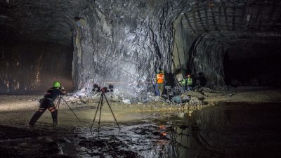
Drone-based photogrammetry survey in a GPS-denied underground mine

Autonomous mine mapping, inspection, and safety assessment in GPS-denied environments
Dr. Bishop’s underground drone research focuses on using autonomous aerial systems, lidar, photogrammetry, and digital mine-mapping workflows to improve safety, visualization, and engineering decision-making in underground mines.
Underground mines are complex, confined, and often GPS-denied environments. Many areas can be difficult, time-consuming, or unsafe for personnel to access using traditional inspection and surveying methods. Drone-based sensing provides a way to collect high-resolution spatial data while reducing worker exposure to hazardous ground conditions, unsupported openings, inaccessible pillars, roof falls, poor visibility, and other underground risks.
His work applies drones and three-dimensional reality capture technologies to create detailed digital models of underground mine workings. These models can support mine visualization, geotechnical mapping, pillar stability assessment, change detection, engineering design, workforce training, and future mine automation. The research integrates mining engineering, autonomous systems, and digital mine-mapping technologies in several key areas:
Lidar and photogrammetry for 3D mine mapping
Drone-based lidar and photogrammetry can be used to generate high-resolution point clouds and digital reconstructions of underground mine openings. These models allow engineers and researchers to visualize mine geometry, map geologic structures, document excavation conditions, and evaluate areas that may be difficult to survey manually.
Ground control and pillar stability
A major application of this research is improving the assessment of underground room-and-pillar mines. Drone-based data can help document pillar geometry, roof and rib conditions, discontinuities, joints, and other features relevant to ground control. These data sets can support pillar stability analysis, numerical modeling, and monitoring of potential changes over time.
Change detection and mine monitoring
Repeat drone surveys can be used to compare underground mine conditions over time. By creating digital records of pillars, entries, ribs, roof conditions, and other mine features, researchers can evaluate whether visible deterioration or deformation is occurring. This approach has potential to support proactive safety management in active, inactive, and legacy underground mines.
Digital mine environments for education and training
Three-dimensional mine models can also be used to create virtual mine environments for teaching, workforce development, safety training, and outreach. These digital environments allow students, researchers, industry partners, and stakeholders to better understand underground mining conditions without needing to physically enter the mine.
For more information, please contact Dr. Richard E. Bishop.